Trekking in the Alps

In this section we present a chapter from the book "Per Alpes, Discovering the Alps in 20 circular walks". Read the tour description below and check other publications of the Alps Convention.

  • Écrins National Park tour
  • Day 1
  • Day 2
  • Day 3
  • Day 4
  • Day 5
  • Day 6
  • Day 7
  • Day 8
  • Day 9
  • Day 10
  • Day 11
  • Day 12
  • Day 13
  • Tourist info

Still wild and unspoilt
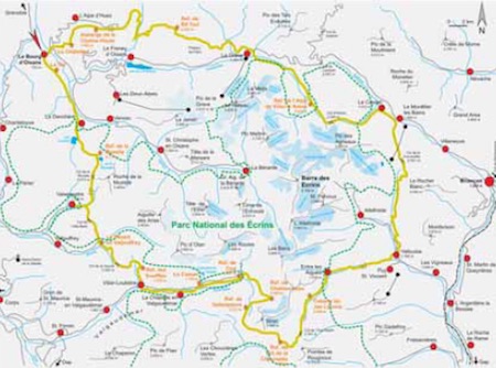

Écrins National Park tour

Trailhead: Le Bourg d’Oisans (722m, bus connection from Grenoble and Briancon)
Highest point: Col de l'Aup Martin (2761m)
Total travelling time:76-81h
Overall height gain/loss: + 10770 m - 10770m
Alp Convention

Route descriptions: The Barre des Écrins rises to 4102m at the heart of the Écrins National Park - the second highest mountain range in France after Mont Blanc. The massif stands out both for its peaks of rock and ice and its contrasting deep, green valleys. The Barre des Écrins range is still wild and unspoilt; it is bordered by the Romanche valley to the north, the Guisane valley to the north-east, the Durance valley to the south and the Drac valley to the west. In 1973 the Écrins became a National Park, covering an area of 2700 km², of which 918 km² are a strictly protected area. Just outside the park is the well-known town of Briançon. On the north side, the ski areas of La Grave and Les Deux-Alpes lie very near to the Park’s borders. The Vénéon valley is located at the very center of the Park with La Bérarde at its head. At this point you are literally surrounded by the highest peaks of the range. A visit to this valley is highly recommended.

Skills required:The tour lasts 13 days. Fitness and endurance are essential. Cols are always very steep and it is important to use careful footwork and to have a head for heights. The route is well marked and huts are privately owned.

Still wild and unspoilt


Écrins National Park tour

Trailhead: Le Bourg d’Oisans (722m, bus connection from Grenoble and Briancon)
Highest point: Col de l'Aup Martin (2761m)
Total travelling time:76-81h
Overall height gain/loss: + 10770m - 10770m
Alp Convention

Le Bourg d’Oisans – Le Châtelard – Auberge de la Combe-Haute


Travel time: 3-4 h.

The beginning of the tour is very easy and comfortable. Walk along the Sarenne valley to reach the small town of Le Châtelard (1448m). After a short descent follow the signs indicating the way to Auberge de la Combe-Haute (1600m).

Accommodation:
Accommodation Hôtel La Forêt de Maronne (Le Châtelard, 1448m): Tel. +33-(0)4-76800006, e-mail: [email protected], www.laforetdemaronne.com, open all year, private.
Auberge de la Combe-Haute (Huez, 1600m): Tel. +33-(0)4-76806138, open all year, private.

Still wild and unspoilt


Écrins National Park tour

Trailhead: Le Bourg d’Oisans (722m, bus connection from Grenoble and Briancon)
Highest point: Col de l'Aup Martin (2761m)
Total travelling time:76-81h
Overall height gain/loss: + 10770m - 10770m
Alp Convention

Auberge de la Combe-Haute – Col de Sarenne – Clavans-le-Haut – Clavans-le-Bas – Besse-en-Oisans – Ref. de Rif Tort

Travel time: 6,5-7h

From Auberge de la Combe-Haute follow the road in and walk up to the Col de Sarenne (2009m). After losing about 500meters you reach the small towns of Clavans-le-Haut and Clavans-le Bas. Follow the road to Besse-en-Oisans (1564m), then follow the signs directing you to Ref. de Rif Tort (2240m), today’s destination.

Accommodation:
Gîte "Le Sarret“ (Besse-en-Oisans, 1564m): Tel. +33-(0)4-76800622, e-mail: [email protected], www.gite-le-sarret.com open all year, private.
Hôtel Alpin (Besse-en-Oisans, 1500m): Tel. +33-(0)4-768008655, e-mail: [email protected], http://www.hotelalpin.fr, open all year, private.
Rif. de Rif Tort (2240m): Tel. +33-(0)4-76802411 or +33-(0)4-76800491, www.oisans.com/montagne/refuges/rif-tort, open frommid June to the beginning of September, private.

Still wild and unspoilt


Écrins National Park tour

Trailhead: Le Bourg d’Oisans (722m, bus connection from Grenoble and Briancon)
Highest point: Col de l'Aup Martin (2761m)
Total travelling time:76-81h
Overall height gain/loss: + 10770m - 10770m
Alp Convention

Ref. de Rif Tort – Col du Souchet – Le Chazelet – La Grave – Ref. de l’Alpe de Villar-d’Arêne

Travel time: 8-8,5h

Today’s route can also be divided into two parts by staying overnight in the town of La Grave. If you wish to reach Ref. de l’Alpe de Villar-d’Arêne without stopping, you need to make an early start. From Ref. de Rif Tort (2240m) walk up Col du Souchet (2365m). On this path you pass by the fascinating Plateau d’Emparis, that in spring looks like a sea of flowers, while in late summer resembles a scrubland. Once you reach La Grave you can stop here for the night, if, on the other hand, you want to continue, bear in mind that there are still 4 hours walk left. After a few ups and downs, follow the signs to the Romanche valley indicating the way to Ref. de l’Alpe de Villar-d’Arêne (2079m).

Accommodation:
Auberge Edelweiss (La Grave, 1491m): Tel. +33-(0)4-76799093, e-mail: [email protected], www.hotel-edelweiss.com, open all year, private.
Ref. de l’Alpe de Villar-d’Arêne (2079m): Tel. +33-(0)4-76799466 o +33-(0)4-76799344, www.refugealpearene.fr, open from mid June to the beginning of September, CAF.

Still wild and unspoilt


Écrins National Park tour

Trailhead: Le Bourg d’Oisans (722m, bus connection from Grenoble and Briancon)
Highest point: Col de l'Aup Martin (2761m)
Total travelling time:76-81h
Overall height gain/loss: + 10770m - 10770m
Alp Convention

Ref. de l’Alpe de Villar-d’Arêne – Col d’Arsine – Le Casset – Le Monêtier-les-Bains

Travel time: 3,5-4 h

From Ref. de l’Alpe de Villar-d’Arêne (2079m) climb up to the Col d’Arsine (2348m), go through the Romanche valley to Guisane valley. At the foot of Montagne des Agneaux descend to Le Casset (1512m) and the spa town of Le Monêtier-les-Bains (1490m).

Accommodation:
Gîte Le Rebanchon (Le Casset, 1512m): Tel. +33-(0)6-80233303 or +33-(0)6-18810954, e-mail: [email protected], www.lauzet.fr, open all year, private.
Gîte Le Flourou (Le Monêtier-les-Bains, 1,490m): Tel. +33-(0)4-92244113, e-mail: [email protected]t, www.leflourou.com, open all year, private.

Still wild and unspoilt


Écrins National Park tour

Trailhead: Le Bourg d’Oisans (722m, bus connection from Grenoble and Briancon)
Highest point: Col de l'Aup Martin (2761m)
Total travelling time:76-81h
Overall height gain/loss: + 10770m - 10770m
Alp Convention

Le Monêtier-les-Bains – Col de l’Eychauda – Chambran – Vallouise

Travel time: 6,5-7h.

From Le Monêtier-les-Bains (1490m) ascend about 1000m and reach Col de l’Eychauda (2425m). Cross the pass and enter Vallouise, where you will surely fi nd some fellow trekkers. This part is in fact very popular and you here you also fi nd the Glacier Blanc, the largest glacier of the Écrins massif. Leaving Col de la Cucumelle (2501m) on your left, descend steadily to the village of Vallouise (1163m).

Accommodation:
Gîte Le Baoüti (Vallouise, 1166m): Tel. +33-(0)4-92234650, www.gite-le-baouti.com, e-mail: [email protected], open all year, private.
Gîte L’Aiglière (Vallouise, 1166m): Tel. +33-(0)4-92235252, e-mail: [email protected], www.pagesperso-orange.fr/gite-aigliere, open all year, private.

Still wild and unspoilt


Écrins National Park tour

Trailhead: Le Bourg d’Oisans (722m, bus connection from Grenoble and Briancon)
Highest point: Col de l'Aup Martin (2761m)
Total travelling time:76-81h
Overall height gain/loss: + 10770m - 10770m
Alp Convention

Vallouise – Entre-les-Aigues – Cabane du Jas Lacroix – Col de l’Aup Martin – Pas de la Cavale – Ref. du Pré de la Chaumette

Travel time: 8-9h

Today you will see the wildest part of the Park, where, with the exception of the huts, there is no sign of tourist exploitation. This is also the longest day of the tour, because you will walk for 9 hours and gain 1600m height. To traverse Vallouise towards Champoléon and Champsaur, cross Col de l’Aup Martin (2761m) and reach Pass de la Cavale, which is almost the same height. The descent to Ref. du Pré de la Chaumette (1805m) is very solitary.

Accommodation:
Ref. du Pré de la Chaumette (1805m): Tel. +33-(0)4-92559534 or +33-(0)4-92507293, www.montagne-virtuel.com/05/refuges/prechaumette/refuge.php, open from mid June to mid September, CAF.

Still wild and unspoilt


Écrins National Park tour

Trailhead: Le Bourg d’Oisans (722m, bus connection from Grenoble and Briancon)
Highest point: Col de l'Aup Martin (2761m)
Total travelling time:76-81h
Overall height gain/loss: + 10770m - 10770m
Alp Convention

Ref. du Pré de la Chaumette – Col de la Vallette – Col de Gouiran – Col de Vallonpierre – Ref. de Vallonpierre

Travel time: 5,5-6h

Today there are three passes to overcome before you reach Ref. de Vallonpierre, and enter Valgaudémar. Leave Ref. du Pré de la Chaumette (1805m) and follow the path heading north towards “Vallon de la Pierre“ till you reach 2080m. Head west, go through Vallon de la Vallette and after steep slope and many zigzags you reach Col de la Vallette (2668m). Descend at 2497m, cross Vallon de Gouiran and reach Col de Gouiran (2597m). Below the steep rock walls, the path runs through Vallon Plat, and after many turns it leads you to Col de Vallonpierre (2607m). Finally descend to Ref. de Vallonpierre (2271m).

Accommodation:
Ref. de Vallonpierre (2271m): Tel. +33-(0)4-92552781 or +33-(0)4-92533156, www.vallonpierre.fr, open from mid June to mid September, CAF.

Still wild and unspoilt


Écrins National Park tour

Trailhead: Le Bourg d’Oisans (722m, bus connection from Grenoble and Briancon)
Highest point: Col de l'Aup Martin (2761m)
Total travelling time:76-81h
Overall height gain/loss: + 10770m - 10770m
Alp Convention

Ref. de Vallonpierre – Ref. de Chabournéou – Ref. du Clot – Le Casset

Travel time: 5-5,5h

Leave Ref. de Vallonpierre (2271m) and cross below the Sirac towards Ref. de Chabournéou (2020m). Reach Ref. du Clot (1397m). Walk along the Séveraisse stream all the way to Le Casset (1135m).

Accommodation:
Ref. de Chabournéou (2020m): Tel. +33-(0)4-92552780, open from mid June to mid September, e-mail: [email protected], http://valgaudemar.free.fr/chabourneou.htm, CAF.
Ref. du Clot (1397m): Tel. +33-(0)4-92552790, open from mid June to mid September, www.valgaudemar.free.fr/xavier_blanc.htm, CAF.
Gîte Le Casset (1135m): Tel. +33-(0)4-92552272, e-mail: [email protected], open from May to October, private.

Still wild and unspoilt


Écrins National Park tour

Trailhead: Le Bourg d’Oisans (722m, bus connection from Grenoble and Briancon)
Highest point: Col de l'Aup Martin (2761m)
Total travelling time:76-81h
Overall height gain/loss: + 10770m - 10770m
Alp Convention

Le Casset – La Chapelle-en-Valgaudémar – Villar-Loubiére – Ref. des Souffl es

Travel time: 4,5-5h

From Le Casset (1135m) reach the small town of La Chapelle-en-Valgaudémar. Follow the road and then the Séveraisse stream, reach Villar Loubière then cut through a lateral valley on the right and you reach the beautiful upslope to Ref. des Souffles (1975m).

Accommodation:
Le Relais de la Vaurze (Villar-Loubiére, 1033m): Tel. +33-(0)4-92552361, e-mail: [email protected], from mid June to mid September, private.
Ref. des Souffles (1975m): Tel. +33-(0)4-92552291, www.valgaudemar.free.fr/souffles.htm, open from mid June to mid September, CAF.

Still wild and unspoilt


Écrins National Park tour

Trailhead: Le Bourg d’Oisans (722m, bus connection from Grenoble and Briancon)
Highest point: Col de l'Aup Martin (2761m)
Total travelling time:76-81h
Overall height gain/loss: + 10770m - 10770m
Alp Convention

Ref. des Souffl es – Col de la Vaurze – Le Désert-en-Valjouffrey

Travel time: 5,5-6h

Cross Col de la Vaurze (2500m) and enter the stunning peaceful Valjouffrey. While admiring the amazing ice covered peaks of Écrins National Park, you reach the small town of Le Désert-en-Valjouffrey (1255m), and this day draws to an end.

Accommodation:
Bar des Écrins (Le Désert-en-Valjouffrey, 1255m): Tel. +33-(0)4-76302701, www.bardesecrins.net, e-mail: [email protected], open all year, private.
Auberge de l’Eterlou (Valjouffrey, 1255m): Tel. +33-(0)4-76302512, open all year, private.

Still wild and unspoilt


Écrins National Park tour

Trailhead: Le Bourg d’Oisans (722m, bus connection from Grenoble and Briancon)
Highest point: Col de l'Aup Martin (2761m)
Total travelling time:76-81h
Overall height gain/loss: + 10770m - 10770m
Alp Convention

Valjouffrey – Col de Côte Belle – Valsenestre

Travel time: 5-6h

Today’s route is not very long. Once you cross Col de Côte Belle (2390m) you reach Valsenestre, another remote valley, where you will find the village carrying the same name: Valsenestre (1294m).

Accommodation:
Gîte Le Béranger (Valsenestre, 1294m): Tel. +33-(0)4-76302088, e-mail: [email protected], open from June to September (May to October for groups), private.

Still wild and unspoilt


Écrins National Park tour

Trailhead: Le Bourg d’Oisans (722m, bus connection from Grenoble and Briancon)
Highest point: Col de l'Aup Martin (2761m)
Total travelling time:76-81h
Overall height gain/loss: + 10770m - 10770m
Alp Convention

Valsenestre – Col de la Muzelle – Ref. de la Muzelle

Travel time: 5,5-6,5h

This is the penultimate day of the tour and it takes you again to the foot of Roche de la Muzelle, and steeply to Col de la Muzelle (2613m). As you descend to Ref. de la Muzelle (2115m), you might find some snowfields on the exposed part to the north. This can make your journey more difficult.

Accommodation:
Ref. de la Muzelle (2115m): Tel. +33-(0)4-76790201, www.muzelle.a-venosc.com, open from the beginning/mid June to the end of September, private.

Still wild and unspoilt


Écrins National Park tour

Trailhead: Le Bourg d’Oisans (722m, bus connection from Grenoble and Briancon)
Highest point: Col de l'Aup Martin (2761m)
Total travelling time:76-81h
Overall height gain/loss: + 10770m - 10770m
Alp Convention

Ref. de la Muzelle – Col du Vallon – Lac Lauvitel – La Danchère – Le Bourg d’Oisans

Travel time: 6,5-7,5h

Today you will wave goodbye to this beautiful corner of the Western Alps, but before you reach Le Bourg d’Oisans you need to tackle a few meters height gain and loss. From Ref. de la Muzelle (2130m) follow the path leading up to Col du Vallon (2541m). Enjoy the superb view for the last time, then descend to Lac Lauvitel and then to La Danchère (989m). Here you reach Vénéon valley, which leads to the heart of the Écrins National Park, ending at the hamlet of La Bérarde in the shadow of the Barre des Écrins. La Bérarde is not on our route but if you wish to extend your tour the valley can be visited by bus. To complete the trek, walk towards La Danchère and head north towards Le Bourg d’Oisans (722m), where, after 13 days, you reach the final destination.

Accommodation:
Gîte Le Lauvitel (La Danchère, 989m): Tel. +33-(0)4-76800677, e-mail: [email protected], www.lelauvitel.com, open all year, private. For further information: Office du Tourisme Le Bourg d’Oisans, www.bourgdoisans.com

Still wild and unspoilt


Écrins National Park tour

Trailhead: Le Bourg d’Oisans (722m, bus connection from Grenoble and Briancon)
Highest point: Col de l'Aup Martin (2761m)
Total travelling time:76-81h
Overall height gain/loss: + 10770m - 10770m
Alp Convention

Useful information

Tourist information
Office du Tourisme Le Bourg d’Oisans: Tel. +33-(0)4-76800325 e-mail: [email protected], www.bourgdoisans.com

Alpine Guides
Guides Office (Bourg d’Oisans): Tel. +33-(0)4-76801127 e-mail: [email protected]www.guidesoisans.com
EPF/Alpe Sports Loisirs (Bourg d’Oisans): Tel. +33-(0)6-22662771 e-mail: [email protected]

Parks
Parc national des Écrins: Tel. +33-(0)4-92402010 e-mail: [email protected]www.ecrins-parcnational.fr

Maps
Libris Sheet 05 Écrins – Grand Rousses – Cerces: 1:60.000
Dauphiné 6 Massif et Parc national des Ècrins: 1:50.000
Carte Touristique 241, Massif des Écrins/ Meije-Pelvoux: 1:25.000
Carte Touristique 243, Massif des Écrins/ Champsaur: 1:25.000

Alpine clubs
FFCAM Fédération française des clubs alpins et de montagne (CAF): Tel. +33-(0)1-53728700, www.ffcam.fr
CAF Grenoble-Oisans: Tel. +33-(0)4-76470422 e-mail: [email protected]
CAF de l’Isère: Tel. +33-(0)4-76870373 e-mail: [email protected]
CAF de Briançon: Tel. +33-(0)4-92201652 e-mail: [email protected]
CAF de Gap: Tel. +33-(0)4-92515514 e-mail: [email protected]
Comité Départemental de la Randonnée Pédestre de l’Isère: Tel. +33-(0)4-76954464 e-mail: [email protected]
Comité Départemental de la Randonnée Pédestre des Hautes-Alpes: Tel. +33-(0)4-9253651 e-mail: [email protected]

Weather France: Tel. +33-(0)8-36680274 or +33-(0)4-50532208 www.france.meteofrance.com

Websites
www.alparc.org
www.via-alpina.org
  • BOOK YOUR TRIP
    Tell us your wants and needs and we will try to plan you the perfect trip

    BOOK

  • CONTACT US
    Please, write to us and ask us your questions, and we will get back to you.

    CONTACT US