Alta Via 1

Alta Via 1 and Alta Via 2 trails are among the most beautiful trails to be found in the Alps. They compose a round circuit around the Aosta Valley on the height, for a distance of 330km. Together they make the track of the Tor des Geants, Tour of Giants, one of the most attractive endurance trail race in the world. All Alta Via trails are very well maintained, and are possible to hike on around a 30 different segments of one day each. Despite it is near all in Europe, it has nothing to envy the most popular Himalayan trekking, with the benefit of nice beds in the Refugios and eat the great local food of the Aosta Valley. Go with us for Alta Via 1 or Alta Via 2 tour!


  • Trail 1
  • Trail 2
  • Trail 3
  • Trail 4
  • Trail 5
  • Trail 6
  • Trail 7
  • Trail 8
  • Trail 9
  • Trail 10
  • Trail 11
  • Trail 12
  • Trail 13
  • Trail 14
  • Trail 15
  • Trail 16
  • Trail 17
Map1 Donnas - Santa Margherita

Trail 1 altitudes Departure: Donnas (330m)
Arrival: Santa Margherita (1250m)
Difference in level: + 1371m - 434m
Duration going there: 5h35
Duration coming back: 4h25
Donnas - Santa Margherita. From the historic neighborhood of the municipality of Donnas, go uphill along the vineyard area until you reach Rovarey. Then, continue along the fairly steep path through the woods to Bondon. The route continues up and down around the mountain, with the local road alternating with stretches of dirt-track road or path, until you come to Place. The route now continues in the municipality of Perloz to the sanctuary of the Madonna della Guardia, from where it moves on at altitude through Bamp to the main village in the municipality.
Once you leave the village, the route goes down and crosses the Lys Valley to the Moretta bridge, built in 1710 and the setting for numerous legends. It then goes back upwards to Tour d’Héréraz, where it crosses the regional road before reaching Remondin.
The route begins then to climb up. From Vers Foillé continue along stretches of the dirt track alternating with stretches of path, until you come to the canal bridge across the Giassit torrent. Cross it and continue along the flat to Salé.
From here, go up the steep mule-track on the right to the Chapel of Santa Margherita, from where a thirty-minute walk will take you to the nearby village of Sassa, where you find a guesthouse. The another alternative is to go down from Toux to the hostel in the village of Lillianes, which will take you about 25 minutes.
Map2 Sassa Rifugio Coda

Trail 2 altitudes Departure: Santa Margherita (1250m)
Arrival: Coda (2280m)
Difference in level: + 1120m – 101m
Duration going there: 4h05
Duration coming back: 3h00
Santa Margherita-Rifugio Coda. From the Chapel of Santa Margherita in the municipality of Lillianes, the route becomes less steep and after a long diagonal stretch between fields/pastureland and woodland, it crosses the Giassit torrent and continues alongside it to Revers, where you can see the “gold mine” if you take a little detour on the little stone arch bridge, before reaching Moline.
Once you come to the dirt-track road, go along it until the first bend, where a path starts out and climbs up to Col Giassit, touching upon Pian da Rouza, Larpit and Le Stret.
Once you have walked right round the Giassit basin you will come to the pass of the same name, where you can see a huge wooden cross erected by the valley-dwellers in 1954.
From here the route continues slightly upwards around the Béchéra basin to the Col della Lace and continues leftwards around Mont Roux on the Biella side, up and down through little deep valleys and touching the peak of Mont Bechit (2320m) on to Col Carisey. From here, proceed along the grassy crest until you reach the Coda Mountain Hut.
Map3 Rifugio Coda Barma

Trail 3 altitudes Departure: Coda (2280 m)
Arrival:Barma (hut under construction) (2062 m)
Difference in level: + 503 m - 707 m
Duration going there: 3h30
Duration coming back: 3h40
Rifugio Coda-Rifugio della Barma. From the Coda Mountain Hut, the route goes around Punta Sella on the right to Col Sella, where the fairly steep descent begins down towards Goudin Lake. After going along the lakeshore, the path winds its way down through the vegetation to the Serrafredda pasture. At the fork in the middle of the pastureland, continue on the right, up over a wooded ridge that leads to the Goillas pasture. Cross the Goillas torrent and go downwards along the dirt-track road for about 500 metres until you come to the Leretta pasture, then begin walking up the path through the fields above the trail: from here, a long up and down path begins that leads through conifer woods and clearings of pastureland to the Crêt Damon and Lion pastures.
From the latter, the route takes left in the pastureland and leads into a steep stretch of woodland that goes down towards Lake Vargno. Go past the mouth of the lake, down from a dam, and after a brief stretch, go up again on the right along a convenient mule-track, along which the procession runs to the Oropa Sanctuary and which is the main access route for the Mont Mars Nature Reserve.
The itinerary continues without difficulty through a very varied environment, touching upon pastureland, stony ground and roches montonnées, on towards Lac Long and after a rocky rise to the basin of the Barma Lakes (Lacs de Barme). From here, walk towards the largest of the lakes, ignoring the fork on the left that indicates the continuation of the Alta Via, and you will soon reach the Barma Mountain Hut.
The hut has not yet been completed, so you can continue along the next 3 1/2 hour stage to the Colle della Vecchia pass. From here a brief detour into the Piemonte region will take you to the Della Vecchia Mountain Hut.
Map4 Barma Niel

Trail 4 altitudes Departure: Barma (2062 m)
Arrival:Niel (1550 m)
Difference in level: + 875 m - 1379 m
Duration going there: 6h00
Duration coming back: 6h35
Rifugio della Barma - Niel. From the Barma Hut, go back along the same route down towards the valley, until you come to a fork. Take right here along a long, easy traverse which runs across two minor cols and leads to the Pierre Blanche and Marmontana pastures. Go across the Col Marmontana into the wild, deep Tourison valley, where the path winds steeply down towards the plain of Lake Chiaro (Leikier).
Once past the lake, at a lock, go down along the main path to the Mianda pasture. Here, turn right and go up again in the direction of the attractive rocky opening known as “Crenna dou Leui”. After the steep crest, the route goes rapidly down to the stony ground below. From here, a long, winding stretch starts out amid stony ground, little lakes and roches montonnées, where the route becomes less clear, although it is well indicated. After a long traverse, the route takes upwards again towards the Colle della Vecchia pass. A pyramidshaped sign indicates the option of reaching the Della Vecchia Hut, in Piemonte; the alternative is to continue the itinerary and head for Niel. After a stretch carved out into the rock, keep right at the fork in the path and continue at altitude until you reach the ridge.
From here, continue on through the vegetation of the shaded mountainside that leads to the Grignatz desor pasture. Take left again at the next fork and, after you cross the torrent, go up an iron ladder and continue until you reach the houses of Kocia. The path leads into thick conifer wood, crosses a wooden bridge, and after a final flight of steps crosses a humpback bridge that leads to the Walser village of Niel, where you will find a stop-off point and a restaurant.
Map5 Niel Gressoneyl

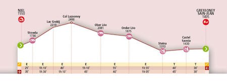
Trail 5 altitudes Departure:Niel (1550 m)
Arrival: Gressoney-Saint-Jean (1405 m)
Difference in level: + 989 m - 1153 m
Duration going there: 6h45
Duration coming back: 7h00
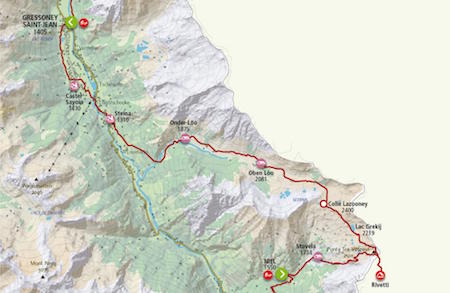
Niel – Gressoney-Saint-Jean. The itinerary starts out from the houses of Niel and runs along a fine mule-track. After a short, steep stretch, it touches on a series of pastures until it reaches the grassy plain of the Stòvela pasture. Here the route becomes steeper until it reaches the basin of the little lake of Grekij, where it flattens out. The path goes past the lake on the right until you reach a pyramid-shaped trail marker.
If you wish to break the stage up into two parts, you can go up to the Mologna Grande col, from which a brief descent into Piemonte will take you to the Rivetti Hut. Otherwise, continue on the left until you come to Col Lazouney, where you will enter a large plateau situated at the head of the deep Loo valley, surrounded by mountain peaks. From here, gentle rises alternate with grassy flat stretches on down to the 17th century chapel of the splendid village of Ober Lòò. After you cross the Lòòbach torrent, the route continues on to the Onder Lòò pasture and then across a wooden bridge.
From here, a steep descent begins that leads quickly down to the bottom of the valley, into the typical Walser village of Lommatto. The itinerary then continues towards the hamlet of Steina down below, and after a brief stretch along the regional road, the route goes onto a dirt road that runs alongside the Lys torrent until the area where the Weissmatten ski slopes begin.
A varied route through fields, patches of woodland, stretches of mule-track and dirt road then touches on the entrance to Savoia Castle (Castel Savoia) before moving onto the convenient “Passeggiata della Regina” trail, which leads to the square in Gressoney-Saint-Jean.
Map6 Gressoney Crest

Trail 6 altitudes Departure: Gressoney-Saint-Jean (1405 m)
Arrival: Vieux Crest (1935 m)
Difference in level: + 1427 m - 890 m
Duration going there: 6h30
Duration coming back: 5h50
Gressoney-Saint-Jean – Crest. From the main car park at Gressoney-Saint-Jean, cross Torrent Lys to the right, over a wooden road bridge, and head up along the unmetalled road which follows the torrent, passing golf courses, to the village of Tschemenoal. Having crossed the torrent to the left, over another road bridge, continue up along an asphalt road for about three hundred meters until you reach the path on the left. From here the route begins to climb, gently at first and then more steeply, through a conifer wood.Thus you reach the typical alpine village of Grossalbezo and Alpenzu Grande Mountain Hut. The trail now takes a long diagonal across the meadows and to reach the summer pastures of Òndermònté. Having passed through a sparsely planted conifer wood and climbed up through the meadows above it, you reach the summer pasture of Loasche.
From here, the route continues over steep slopes to Col Pinter. The path descends along a small bouldered valley and then crosses a grassy plain as far as a rocky formation. Beyond this, after numerous twists, it reaches the meadows below and on to Cunéaz.
From here the route, after a short time, descends to Crest and Vieux Crest Mountain Hut.
Map6 Gressoney Crest

Trail 7 altitudes Departure: Vieux Crest (1935 m)
Arrival: Grand Tournalin (2535 m))
Difference in level: + 1067 m - 452 m
Duration going there: 4h50
Duration coming back: 4h10
Crest – Rifugio Grand Tournalin. From Vieux Crest Mountain Hut, take first the track and then follow the unmetalled road leading to the rural hamlet of Sousun. Passing through it, the route heads out over level ground to Charcherioz. Continuing on from here for a short while, on the unmetalled road and then along the track, the route climbs up to the G.B. Ferraro and Guide di Frachey Mountain Huts. The path now descends towards the valley, through the summer pasture of Raccard to the village of Saint-Jacques. Crossing the road bridge over Torrent Evançon, the route turns right along the path which climbs up through meadows and sparse woods.
Just after the summer pastures of Croues you reach an unmetalled road which the path crosses at various points, until it reaches the summer pasture of Nannaz inferiore and then Nannaz superiore. The route now continues entirely on unmetalled road, which climbs up as far as Grand Tournalin Mountain Hut.
Map8 Gressoney Crest

Trail 8 altitudes Departure: Grand Tournalin (2535 m)
Arrival: Valtournenche (1520 m)
Difference in level: + 294 m - 1317 m
Duration going there: 3h15
Duration coming back: 4h30
Rifugio Grand Tournalin – Valtournenche. From Grand Tournalin Mountain Hut descend for a short while on the unmetalled road and then take the path to the right. Having made a long diagonal crossing through meadows, you reach a rocky cliff. Having passed this, the trail continues to climb over grassy and rocky humps until it reaches Col di Nannaz.
From here it descends into a grassy valley just below the pass, before climbing upwards a little way to Col des Fontaines on a rocky ridge. The route now begins its descent, among wide open meadows, reaching the summer pasture of Champ-Sec and, further down, the district of Cheneil.
It continues its descent, entering a conifer wood and passing beside the summer pastures of Promindoz, situated on a grassy panoramic plain, before completing the descent at the village of Crétaz (Valtournenche).
Map9 Valtournenche Rifugio Barmasse

Trail 9 altitudes Departure: Valtournenche (1520 m)
Arrival: Barmasse (2157 m)
Difference in level: + 682 m - 25 m
Duration going there: 2h25
Duration coming back: 1h50
Valtournenche – Rifugio Barmasse. From the village square of Crétaz cross the asphalt road and take the path that descends to join the track. Having crossed the Torrent Marmore it rises back up to the village of Valmartin. Here, take the path through the meadows which climbs steeply, passing through a wood.
After a long diagonal stretch, it leads to several hydro-electrical constructions. The trail then reaches the summer pastures of Falegnon and continues across a slope into a valley until it reaches the artificial dam at Tsignanaz.
From here, continue along the path that takes left, downstream from the wall of the dam, and go past the back of the house at the hydroelectric plant, then continue along a brief stretch of dirt road and, just after the bend, take the path on the left that leads straight to the Barmasse Mountain Hut.
Map10 Rifugio Barmasse Rifugio Cuney

Trail 10 altitudes Departure: Barmasse (2157 m)
Arrival: Cuney (2652 m)
Difference in level: +1233 m - 1552 m
Duration going there: 6h15
Duration coming back: 5h45
Rifugio Barmasse - Rifugio Cuney. From the Barmasse Hut, continue along the dirt-track road for a brief stretch and then take the path on the left that goes down to the pastureland of Cortina Superiore; then go back onto the dirt-track road and when you come to the fork, go down on the left towards the pastureland of Cortina Inferiore.
Just before the pasture, take the path on the right that runs through a humid area into the wood and comes out onto a dirt road. Cross the road and go along the path that runs past the Ersa Dessus pasture and on to the col Fenêtre d’Ersa. From the col, go slightly downwards and take the dirt-track road that leads to the Vareton pasture. From here, continue along the path through the pastureland to the Gran Raye pasture and then to Lake Tsan, where you will find the Tsan bivouac. From here the route climbs up to the col Fênetre de Tsan, from where it begins to go down, first around a series of bends and then along a long traverse on the mountainside, which ends at the plateau with the Reboulaz bivouac and the magnificent Luseney Lake.
Cross the torrent that emerges from the lake and start on up, passing by a number of ruins.A steep slope climbs up to Col Terray, from which a rather steep descent begins, and the route then continues round the mountainside, moving up and down until you reach a grassy plateau. Cross a torrent towards the left, and after a little promontory you will come to the Cuney Mountain Hut.
Map11 Rifugio Cuney Oyace

Trail 11 altitudes Departure: Cuney (2652 m)
Arrival: Oyace (1397 m)
Difference in level: + 498 m - 1697 m
Duration going there: 5h15
Duration coming back: 6h35
Rifugio Cuney - Oyace. From Cuney mountain hut the route descends for a short distance across several ridges, then heads to the right, skirting the base of a rocky area before rising slightly to a grassy plain. After a short climb to the right it reaches Col Chaleby. From here, the path descends the steep slope to a basin, where there are the remains of a mountain chalet, and then climbs sharply, crossing a rocky stretch to reach Rosaire Clermont bivouac.
Climbing up the steep rocky slope, you reach Col de Vessonaz. The descent, at first, passes steeply through rock debris, after which, keeping to the right under a modest rocky buttress, you reach the summer pastures of Arp Damon. The route continues on to the right into a small rocky valley, at the end of which there is a conifer wood, leading to the vast grassy plain of the summer pastures of Arp Vieille.
From here the path crosses the plain, enters a wood and descends until it reaches a clearing. Past the Betenda bridge over Buthier creek, the trail goes up and through the woods to Betenda alp, it reaches the Tour d’Oyace bifurcation, then it goes down by the town of Oyace, where you’ll be able to spend the night in a dorm starting in Summer 2015. For now you can take a bus or walk (20 min) to Bionaz where you can find a hotel. Otherwise after another 20 min walk you reach either a farm house or a hostel.
Map12 Oyace Rey

Trail 12 altitudes Departure: Oyace (1397 m)
Arrival: Rey (Ollomont) (1393 m)
Difference in level: + 1146 m – 1157 m
Duration going there: 5h45
Duration coming back: 5h50
Oyace - Rey (Ollomont). From the village of Oyace, the path climbs up through meadows, cutting across the dirt road. Reaching the summer pastures of Eclevey, it enters a conifer wood where it begins to rise rapidly, arriving at the summer pastures of Suchéaz. Continuing on up through woodland it arrives at the summer pastures of Brison.
After a long, mid-slope diagonal stretch, the path rises up a tight series of curves of the last steep slope leading to Col Brison. From here, there is a fairly long initial descent through meadows and rocky outcrops, until you reach a very scenic, flat area. From here, a long mid-slope diagonal begins, leading to the summer pastures of Berrio Superiore.
At this point, take the unmetalled road which descends gradually, first through meadows and then woodland, until it reaches Ollomont. After a few more minutes along the asphalt road, you reach the village of Rey.
Map13 Rey Rifugio Champillo

Trail 13 altitudes Departure: Rey (Ollomont) (1393 m)
Arrival: Letey Champillon (2465 m)
Difference in level: + 1038 m
Duration going there: 3h05
Duration coming back: 1h55
Rey (Ollomont) - Rifugio Champillon Just above the village of Rey, take the footpath which climbs up through a dense conifer wood, passing the old summer pastures of Prumayes, and into meadows. After a short stretch of unmetalled road, you reach the summer pastures of Champillon (nearby you can admire the small church of Notre- Dame-des-Neiges).
Continue on up the unmetalled road until you reach, after a short while, the summer pastures of Pessinoille. From here, the path passes on up through steep green meadows to the summer pastures of Tsa de Champillon and, a little further up, to Letey Champillon Mountain Hut.
Map14 RifugioChampillonSaint-Rhemy

Trail 14 altitudes Departure: Letey Champillon (2465 m)
Arrival: Saint-Rhémy (1600 m)
Difference in level: + 522 m - 1324 m
Duration going there: 5h05
Duration coming back: 5h55
Rifugio Champillon - Saint-Rhémy. From Letey Champillon Mountain Hut, the path tackles a steep grassy spur with a series of bends, arriving at Col Champillon. The first stretch of descent is very steep as far as the ruins of the summer pastures of Crou de Bleintse. After this point, the route becomes more gentle and begins a long mid-slope diagonal crossing towards the right, to the summer pastures of Pointier Superiore.
After descending the last barren grassy slopes, you then reach the summer pastures of Pointier Inferiore. Here you follow a stretch of unmetalled road towards the left and then return to the footpath. Having crossed a small conifer wood, the path crosses the Torrent Menouve over a wooden bridge and returns to the dirt road.
After a short climb, take the path to the right leading to the village of Prailles Superiore. Just above the houses the path enters meadows, following a long level route towards the village of Eternod Superiore, which you reach after a short stretch of asphalt road. From the village, a wide footpath climbs up to join an unmetalled road in woodland. Here, bear left and follow it for a distance until you arrive at a bend in the asphalt road, where you head down to the village of Saint-Rhémy.
Map15 Saint Rhemy Rifugio Frassati

Trail 15 altitudes Departure: Saint-Rhémy (1600 m)
Arrival: Frassati (2540 m)
Difference in level: + 905 m - 20 m
Duration going there: 3h50
Duration coming back: 2h50
Saint-Rhémy - Rifugio Frassati. From the village of Saint-Rhémy cross the road bridge over the Torrent Grand Saint-Bernard. About 100 m along the unmetalled road, take the wide footpath to the right which climbs up to the village of Laval.
Then follow the asphalt road through the villages of Couchepache and Mottes and, after a downward stretch, take the unmetalled road which passes under the motorway viaduct and continues on level ground as far as the summer pastures of Devies. A little further on, take the footpath to the right, alongside a dry-stone wall, then climb up across meadows to the summer pastures of Merdeux Inferiore.
From here there is a short stretch of unmetalled road as far as the summer pastures of Côtes, before the route takes a mid-slope path across to the summer pastures of Moindaz. It then climbs once again, through wide green meadows, to the summer pastures of Tsa de Merdeux. After crossing several streams and climbing a steep grass spur, you arrive at the plain of Lake Merdeux.
Map16 Frassati Bonatti

Trail 16 altitudes Departure: Frassati (2540 m)
Arrival: Walter Bonatti (2025 m)
Difference in level: + 430 m – 903 m
Duration going there: 3h05
Duration coming back: 3h30
Rifugio Frassati - Rifugio Walter Bonatti. From the plain of Lake Merdeux the path rises through green meadows until it reaches a basin of rocky detritus below a picturesque jagged rocky ridge. Having crossed the basin, a long diagonal stretch of path continues on to the left and, after a tight series of turns, passes the last steep stretch of rocky debris leading up to Col Malatrà. The mid-slope descent through rocky boulders takes you eventually to several grassy ridges that lead down to a vast grassy plain, through which a torrent runs. Following the stream to the right, the route leads across the whole plain to reach the summer pastures of Giué Superiore.
Having crossed the torrent to the left over a small wooden bridge, you arrive after a few metres of descent at the summer pastures of Malatrà Superiore. From here, after a short distance, the route descends to the summer pastures of Malatrà Inferiore and Walter Bonatti Mountain Hut.
Map17 Bonatti Courmayeur

Trail 17 altitudes Departure: Walter Bonatti (2025 m)
Arrival: Courmayeur (1223 m)
Difference in level: + 183 m -1024 m
Duration going there: 3h50
Duration coming back: 4h45
Rifugio Walter Bonatti - Courmayeur. From Walter Bonatti Refuge the route descends for a short way through meadows, then bears to the left and leads to the summer pastures of Sécheron. A mid-slope path climbs slightly towards the summer pastures of Arminaz Inferiore, which you reach after a short descent.
Having crossed the torrent over a wooden bridge, the path continues to the right, on level ground between shrubs and rhododendrons, to the summer pastures of Lèche. Then continue on, through green meadows, passing just above the summer pastures of Leuchey Superiore. From here, entering a conifer wood, there is a slight rise up to a grassy ridge, beyond which is the Giorgio Bertone Mountain Hut. From the refuge, the path drops steeply, entering a dense conifer wood and after a series of numerous bends, arrives at an unmetalled road. Then, the route follows alternate stretches of the road and the footpath that intersects it.
Having crossed a road bridge over the Torrent Tsapy, the continues entirely on the road. This descends, becomes asphalt, and crosses the village of Villair Superiore. Then, at a major crossroads, turn left and enter the town of Courmayeur, just by the church.
  • BOOK YOUR TRIP
    Tell us your wants and needs and we will try to plan you the perfect trip

    BOOK

  • CONTACT US
    Please, write to us and ask us your questions, and we will get back to you.

    CONTACT US