Trekking in the Alps

In this section we present a chapter from the book "Per Alpes, Discovering the Alps in 20 circular walks". Read the tour description below and check other publications of the Alps Convention.

  • Maritime Alps tour
  • Day 1
  • Day 2
  • Day 3
  • Tourist info

The giant of the Cottian Alps
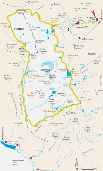

Monte Viso tour

Trailhead: Crissolo (1398m, regular bus connections)
Highest point: Colle delle Traversette (2950m)
Total travelling time:19,5-21h
Overall height gain/loss: + 2788m - 2788m
Alp Convention

Route descriptions: Monte Viso with an altitude of 3841m is the highest summit in the Cottian Alps, its massive rocky pyramid regarded by many as the most beautiful summit of the entire alpine area. For years the local people believed Monte Viso to be the highest mountain in the Alps, because its peak is between 500 to 1000m higher than surrounding ones. Probably only a few people also know that at the foot of this mountain springs the longest river in Italy, the Po. There are many legends surrounding Monte Viso; it is said that Hannibal built the tunnel "Buco diViso" below the Punta delle Traversette and used it to return to the north with his elephants. Actually the tunnel was built in the 15th century for commercial reasons, mostly linked to salt trade. The ascent of Monte Viso isn’t easy. In addition to several ascending and descending slopes, there is also some grade II climbing. Furthermore, during the summer months Monte Viso is often covered by clouds. Despite all difficulties, this three-day tour (which could be extended) is not to be missed, because the Cottian Alps offer everything a climber could wish for: solitude, peace and quiet and a splendid alpineexperience.

Skills required: The Monte Viso tour is relatively short, however the challenges this route presents should not be underestimated, careful footwork and endurance are essential. Up until the start of summer, the route entails crossing steep snowfields. It is therefore advisable to bring crampons. If you wish to go through the 75m tunnel "Bucodi Viso", below the Punta delle Traversette, a head torch or a pocket torch is necessary.

The giant of the Cottian Alps


Monte Viso tour

Trailhead: Crissolo (1398m, regular bus connections)
Highest point: Colle delle Traversette (2950m)
Total travelling time:19,5-21h
Overall height gain/loss: + 2788m - 2788m
Alp Convention

Crissolo – Pian Melze – Rif. Pian del Re – Colle del Viso – Rif. Quintino Sella


Travel time: 5,5-6h.

Most of our fellow climbers/trekkers reach the Pian del Re hut (2020m) by car and use that as their trailhead, while our starting point is Crissolo (1398m), because this location is accessible by public transport. The first uphill slope takes approximately 3 hours, it follows the long GTA path in the Pian Melze (1714m) and takes you to Pian del Re hut (2020m). After lunch, leave the hut and walk towards the idyllic Lake Fiorenza (2113m), where you find a carved rock indicating the River Po spring. The landscape around Lake Chiaretto (2261m), with a view on the towering northeast crag of Monte Viso, is an experience you must not miss. The path then crosses a beautiful valley and leads you to Colle del Viso (2650m). Follow it until you see the Quintino Sella hut (2640m). If you get to the hut early enough and still feel up for more, you could climb over Viso Mozzo (3019m). From this point, the view of Monte Viso is dramatic (the climb takes about 1½ h).

Accommodation:
Rif. Pian del Re (2020m): Tel. +39-0175-94967 or +39-349-3932559, open from June to September, private.
Rif. Quintino Sella (2640m): Tel. +39-0175-94943, open from the end of June to the end of Septmeber, CAI.

The giant of the Cottian Alps


Monte Viso tour

Trailhead: Crissolo (1398m, regular bus connections)
Highest point: Colle delle Traversette (2950m)
Total travelling time:19,5-21h
Overall height gain/loss: + 2788m - 2788m
Alp Convention

Rif. Quintino Sella – Passo Gallarino – Passo San Chiaffredo – Grange del Rio – Rif. Vallanta

Travel time: 6-6,5h

Today’s route is lengthy; it includes two passes, a descent and a final strenuous ascent. Gallarino Pass (2727m) and San Chiaffredo Pass (2764m) are reached in short time. From here, the path takes a steep downhill slope and just before Lake Lungo it crosses an unusual landscape with rock cairns. As you reach the lowest point of the tour, almost 1900m, take the path running through the long Vallanta valley which takes you as far as the Vallanta hut (2450m).

Accommodation:
Rif. Vallanta (2450m): Tel. +39-0175-956025, open from June to September, CAI.

The giant of the Cottian Alps


Monte Viso tour

Trailhead: Crissolo (1398m, regular bus connections)
Highest point: Colle delle Traversette (2950m)
Total travelling time:19,5-21 h
Overall height gain/loss: + 2788m - 2788m
Alp Convention

Rif. Vallanta – Passo di Vallanta – Ref. du Viso – Colle delle Traversette – Rif. Pian del Re – Pian Melze – Crissolo

Travel time: To Crissolo (part 1) 8-8,5h, To Pian del Re (part 2) 5,5-6h

From the Vallanta hut (2450m) the track unfolds steeply downhill all the way to the Vallanta Pass (2811m), sunken deep between the north-west crag of Monte Viso and Mount Losetta on the east side. For a short distance the path takes you into French territory, then starts descending towards Ref. du Viso (2460m), just before gaining height by climbing Colle delle Traversette (2950m). Just before the Colle delle Traversette it is possible to take the deep tunnel "Buco del Viso" (only if you have a pocket torch or a head torch); otherwise you could simply cross over the hill. The descent to the Pian del Re hut is rather steep, however, this trail takes you quickly to the hut by crossing beautiful pastures. At this point, those who started the journey in the PIan del Re hut may now feel free to relax, while for those who left from Crissolo, there is still one final 2 – 2½ hour descent to the Po valley.

Accommodation:
Rif. Pian del Re (2020m): Tel. +39-0175-94967 or +39-349-3932559, open from June till September, private.

The giant of the Cottian Alps


Monte Viso tour

Trailhead: Crissolo (1398m, regular bus connections)
Highest point: Colle delle Traversette (2950m)
Total travelling time:19,5-21h
Overall height gain/loss: + 2788m - 2788m
Alp Convention

Useful information

Tourist information
Ufficio Turistico Crissolo: Tel. +39-0175-940131 e-mail: [email protected]
Ufficio Turistico Sampeyre: Tel. +39-0175-977152 www.vallevaraita.cn.it
Office de Promotion de Tourisme en Queyras: Tel. +33-(0)4-92467618, www.queyras.com

Alpine Guides
Guide alpine del Monviso: Tel +39-348-3133349 e-mail: [email protected]
Bureau de Guides du Queyras Saint-Veran: Tel. +33-(0)492-458587, www.guidesqueyras.com

Further information
Parco del Po Cunese: Tel. +39-0175-46505 e-mail: [email protected]www.parcodelpocn.it
Tourist guides La Grisaille S.n.c.: Tel. +39-0175-85679

Weather
Piedmont: www.regione.piemonte.it
Italy: www.meteo.it, www.meteoitalia.it, www.meteoam.it
France: Tel. +33-(0)8-36680274 or +33-(0)4-50532208 www.meteofrance.com

Maps
Map IGC “Monviso, Samoeyre, Bobbio Pellice” Sheet 106: 1:25.000
Map IGN “Alpes sans Frontieres, Sheet 8 (Monte Viso) Haut Queyras“: 1:25.000

Alpine clubs
Club Alpino Italiano (CAI), Sezione di Saluzzo: Tel. +39-0175-249370 e-mail: [email protected], www.caisaluzzo.it
FFCAM Federation francaise des clubs alpins et de montagne (CAF): Tel +33-(0)1-53728700, www.ffcam.fr

Public transport
Allasia Autolinee: www.allasiaautolinee.com
Atibus: www.atibus.it
Dossettobus: www.dossettobus.it

Websites
www.grande-traversee-alpes.com
www.via-alpina.org
  • BOOK YOUR TRIP
    Tell us your wants and needs and we will try to plan you the perfect trip

    BOOK

  • CONTACT US
    Please, write to us and ask us your questions, and we will get back to you.

    CONTACT US