Trekking in the Alps

In this section we present a chapter from the book "Per Alpes, Discovering the Alps in 20 circular walks". Read the tour description below and check other publications of the Alps Convention.

  • Grossglockner tour
  • Day 1
  • Day 2
  • Day 3
  • Day 4
  • Day 5
  • Day 6
  • Day 7
  • Tourist info

Seven days around the highest Austrian mountain
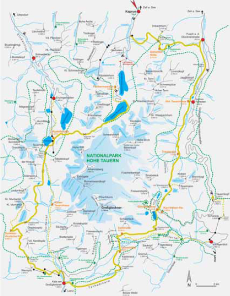

Grossglockner tour

Trailhead: Kaprun (786m regular bus connection with the Zell am See station)
Highest point: Gradetzsattel (2826m)
Total travelling time:43-46,5 h
Overall height gain/loss: + 6460m - 7620m
Alp Convention

Route descriptions: In the past, a circular tour of the highest mountain in Austria was only a dream for trekkers. Since 2004, it is finally possible to trek around the 3798m Grossglockner in seven days and appreciate it in all its majestic beauty. The Grossglockner lies at the centre of the Hohe Tauern National Park, a protected area of 1836 km² comprising not only a dramatic mountain landscape, but also an incredible cultural heritage in which traditional mountain agriculture still predominates. The Grossglockner area hides several ancient paths that climb over steep slopes allowing you to enjoy marvellous views of the surrounding icy three-thousanders and the deep narrow valleys with their rushing glacial streams. The National Park straddles the provinces of Carinthia, Salzburg and Tyrol and offers an exceptional variety of fl ora and fauna. Its history is long and complex. During the 1970s-80s it took considerable determination and many strenuous battles to stop the construction of cableway stations and power plants that would have negated the ideal of a national park. This tour takes eight days and follows a scenic trail running along the vegetation line, however you can shorten the journey by taking different routes which are sometimes easier than the ones proposed here.

Skills required: This tour reaches high altitude, therefore even if you will not be crossing rocky terrain or a glacier it is still important not to underestimate the difficulties you may encounter. Once again, careful footwork, a head for heights and endurance are essential. The trail can be quite hazardous because of the altitude combined with old snow lying on steep north-facing slopes, even in the summer. Therefore you should carry crampons.

Seven days around the highest Austrian mountain


Grossglockner tour

Trailhead: Kaprun (786m regular bus connection with the Zell am See station)
Highest point: Gradetzsattel (2826m)
Total travelling time:43-46,5 h
Overall height gain/loss: + 6460m - 7620m
Alp Convention

Kaprun – Stausee Mooserboden – Kapruner Törl – Berghotel Rudolfshütte


Travel time: 6-6,5 h (from “Steinerne Stiege”, medium difficulty) or 6-6,5 h (from Hinterer Schafbichl, easy)

The resort of Kaprun (786m) lies on the edge of the National Park and makes the perfect trailhead for this tour, easily accessible by public transport from Zell am See station. From Kaprun, take the bus to Kesselfall-Alpenhaus and from here go through the Lärchwand Tunnel to reach the lower station of the funicular railway “Lärchwand- Schrägaufzug” (1209m) – it takes only five minutes to reach the upper station Seehöhe (1640m). By bus once again, ride to Stausee Wasserfallboden (1672m) and you finally reach Stausee Mooserboden (2036m, last stop). Once you are in at Stausee Mooserboden cross the dam and take path 716 along the south-eastern shore of the reservoir and up the valley beyond. The path winds steadily up to the Kapruner Törl (2639m) following the crest of a large moraine. From Kapruner Törl head down towards Übelkar and then, through Vorderer Eisbichl, the path slopes downhill towards Ödenwinkelkees stream, which you cross as you get to Gaulmöselsteg (2028m). After gaining 160m you can choose between the “Steinerne Stiege” trail, which is short but steep and partly equipped with cables and ladders, or a longer, more gentle route on to the Hinterer Schafbichl.

Accommodation:
Fürthermoaralm (1803m): Tel. +43-(0)6547-7158-23435, e-mail: [email protected], www.fuerthermoar.at, open from June to the beginning of October, private.
Berghotel Rudolfshütte (2311m): Tel. +43-(0)6563-8221, e-mail: [email protected], www.rudolfshuette.at, open from mid June to the end of October, private.

Seven days around the highest Austrian mountain


Grossglockner tour

Trailhead: Kaprun (786m regular bus connection with the Zell am See station)
Highest point: Gradetzsattel (2826m)
Total travelling time:43-46,5 h
Overall height gain/loss: + 6460m - 7620m
Alp Convention

Berghotel Rudolfshütte – Kalser Tauern – Silesia Höhenweg – Sudetendeutsche Hütte

Travel time: 7,5-8 h

Leaving the Rudolfshütte (2311m), head south and walk down towards Weißseethen up again to the Kalser Tauern (2518m). Here you go from Salzburg province to Tyrol. In Tauernbrünnl/Erdiges Eck (2220m) follow the path “Silesia Höhenweg”, not very steep initially, heading to Plateau des Seetroges, where the path trends rapidly downwards all the way to Dorfental. As you walk past a rocky crest (Spinnevitrol), the path forks and you head to the Kalser Tauernhaus (2512m). From here the path takes you by lush meadows and streams. From Muntanitzschneid follow the steep path crossing a saddle and you reach Bloibalfelen (2684m). On reaching the Gradetzsattel (2826m) continue through what used to be the basin of the Gradetzkees glacier. After a few minutes you finally reach the Sudetendeutsche Hütte (2650m).

Optional Route:
As an alternative to the “Silesia Höhenweg”, you can descend from the Tauernbrünnl/ Erdiges Eck (2220m) to the Kalser Tauernhaus (1755m) and either stay overnight there or keep going until you reach Kals. If you are up to it, you could also ascend from Kalser Tauernhaus to Muntanitztrog (2500m) following path 514, leading up to Silesia Höhenweg and taking you to the Sudetendeutsche hut via Bloibalfelen and the Gradetzsattel (2826m).

Accommodation:
Sudetendeutsche Hütte (2650m): Tel. +43-(0)4875-6466, www.alpenverein-sudeten.de, open from the end of June to mid/end of September, DAV.
Kalser Tauernhaus (1755m): Tel. +43-(0)664-9857090, e-mail: [email protected], www.kalser-tauernhaus.de, open from the end of May to mid October, DAV.

Seven days around the highest Austrian mountain


Grossglockner tour

Trailhead: Kaprun (786m regular bus connection with the Zell am See station)
Highest point: Gradetzsattel (2826m)
Total travelling time:43-46,5 h
Overall height gain/loss: + 6460m - 7620m
Alp Convention

Sudetendeutsche Hütte – Dürrenfeldscharte – Hohes Tor – Aussig- Teplitzer-Weg – Kals am Großglockner

Travel time: 5-5,5 h

Leave the Sudetendeutsche hut (2650m) and head east till the path forks. Take the track directing you to “Sudetendeutscher Höhenweg” which leads without much effort to Stellachkar (2790m). Soon after, the path starts sloping uphill and becomes steep and rocky. The path at this stage is equipped and leads all the way to the Dürrenfeldscharte (2823m), a notch in a rocky ridge. Descending to Dürrenfeld is again very easy, the landscape is really varied and, at a distance, you can see the green broad saddle of Hohes Tor (2477m). From Hohes Tor follow the path running below the Blauer Knopf and the Blauspitze, and then take the path “Aussig-Teplitzer- Weg”. After a few ups and downs you descend to the “Kapelle der verunglückten Bergsteiger” (The chapel of the ill-fated alpinists) (2080m). After a short walk along the ski runs, enter the wood and reach Gasthaus Glocknerblick (1944m), then follow the path as it curves down to Kals-Großdorf (1336m). After one km (15 minutes walk) you finally arrive at the town of Kals am Großglockner (1325m).

Accommodation:
Ködnitzhof (1325m): Kals/Ködnitz Nr. 16, Tel. +43-(0)4876-8201, e-mail: [email protected], www.koednitzhof.at, open all year, private.
For further information: Tourismusinformation Kals a. Gr.

Seven days around the highest Austrian mountain


Grossglockner tour

Trailhead: Kaprun (786m regular bus connection with the Zell am See station)
Highest point: Gradetzsattel (2826m)
Total travelling time:43-46,5 h
Overall height gain/loss: + 6460m - 7620m
Alp Convention

Kals am Großglockner – Glorergarten Alm – Tschadinmähder – Peischlachtörl – Glorer Hütte – Salmhütte

Travel time: 7-7,5 h

From Kals am Grossglockner town centre, follow the path that first crosses the wood along the Ködnitzbach. Then, after a few turns, you will see a sign indicating the way to “Lesachriegel”. Take the steep uphill slope to Mount Glorergarten (1809 m) and cross the enchanting larch forests all the way to Tschadinalm. Crossing classic alpine terrain with a stunning view of the Grossglockner, you reach the deep cleft of the Peischlachbach stream. Ascend 200m to the Peischlachtörl (2480m). To reach the Glorer hut (2651m), the path takes you once more by steep crags in a rocky landscape. Take a reinvigorating break before tackling the last part of the journey through the Glatzschneid to the Salmhütte (2638m).

Accommodation:
Glorer Hütte (2651m): Tel. +43-(0)664-3032200, open from the end of June to the beginning of October, DAV.
Salmhütte (2638m): Tel. +43-(0)4824-2089, e-mail: [email protected], www.salmhuette.at, open from mid June to the end of September, OeAV.

Seven days around the highest Austrian mountain


Grossglockner tour

Trailhead: Kaprun (786m regular bus connection with the Zell am See station)
Highest point: Gradetzsattel (2826m)
Total travelling time:43-46,5 h
Overall height gain/loss: + 6460m - 7620m
Alp Convention

Route A

Salmhütte – Stockerscharte – Stausee Margaritze – Glocknerhaus

Travel time: 3-3,5 h.

Leave the Salmhütte (2638m) and take the slope going slightly uphill towards the meadows at the foot of the majestic Schwerteck, Schwertkopf and Hinterer and Mittlerer Leiterkopf towards Stockerscharte (2501m). The ground here is crumbly and the path gets increasingly steep in Leitertal, requiring more concentration. The first part of the descent takes you again across a rocky landscape, but it soon leads to lush pastures. From Stauseemargaritze (2000m) follow the dyke heading north and after one last upslope you reach the Glocknerhaus hut (2132m).

Route B

Salmhütte – Leiteralm – Bruechet Alm – Heiligenblut

Travel time: 4-4,5 h.

From the Salmhütte hut (2638m) take the path to Leikaufbichl (2353m), go past the Leiterochsenhütte (2161m) and you arrive at Leiteralm (2024m). Walk along the Leiterbach and descend to Trogalm (1862m), then follow the sloping path till it forks. Here take the trail directing you to Bruechet Alm (1554m). Soon after, you descend to the so called “First” and after a few turns, you reach Gröbig car park. Finally, follow river Möllfl uss and reach Heiligenblut (1291m).

Accommodation:
Glocknerhaus (2132m): Tel. +43-(0)4824-24666, e-mail: [email protected], www.glocknerhaus.com, open from the beginning of May to the end of October, OeAV.
Karl-Volkert-Haus (2150m): Tel. +43-(0)4824-2518, e-mail: [email protected], www.glocknerblick.at, open from the beginning of May to the end of October, private.
For further information: TauernAlpin - NationalparkRegion Hohe Tauern Kärnten.

Seven days around the highest Austrian mountain


Grossglockner tour

Trailhead: Kaprun (786m regular bus connection with the Zell am See station)
Highest point: Gradetzsattel (2826m)
Total travelling time:43-46,5 h
Overall height gain/loss: + 6460m - 7620m
Alp Convention

Route A:

Glocknerhaus – Untere Pfandlscharte – Ferleiten – Fusch

Travel time: 7,5-8 h

Leave the Glocknerhaus (2132m) and walk up to the meadows, followed by the Untere Pfandlscharte (2663m) amid a landscape of glacial moraines. Walking on a moraine and on snow residues, follow the signs directing you to Späherbrünnl (2295m) and after many zigzags you reach Trauneralm (1522m). From here, walk along the road leading you across the Ferleitental pasture and all the way to the Tauernhaus. If you do not feel able to reach Fusch an der Glocknerstraße on foot, you can catch the bus to Mautstelle in Ferleiten. If, instead, you decide to walk, head to Mount Wimmer (960m) and after two hours and a few ups and downs, you eventually reach your final destination: Fusch an der Glocknerstraße (813m).

Route B:

Heiligenblut – Schareck – Hochtor – Fusch

Travel time: 3 h

From Heiligenblut (1291m) take the cableway and reach the upper station (2593m). From here, walk all the way to the Schareck peak (2604m). The path runs initially on flat ground, then soars up (this part is equipped). Descend to Mauskarscharte (2507m). Take the instructional trail “Geo-Lehrpfad” that leads you, after a short climb, to Roßköpfl (2588m). Crossing the mountain on the right flank, take the “Klagenfurter-Jubiläumsweg” path. Head west towards Tauernkopf (2626m) and after a short and steep ascent to Hochtor (2575m), follow the track as it curves around and leads you to the Großglockner-Hochalpenstraße tunnel (2505m). Finally, you can reach Fusch an der Glocknerstrasse by bus.

Accommodation:
Trauneralm (1522m): Tel. +43-(0)6545-7458, e-mail: [email protected], www.lukashansl.at, beginning of June to beginning of October, private.
Landgasthof-Hotel Römerhof (Fusch, 813m): Tel. +43-(0)6546-218-0 e-mail: [email protected], www.roemerhof-fusch.at, open all year, private.
Landgasthof-Hotel Wasserfall (Fusch, 813m): Tel. +43-(0)6546-249, e-mail: [email protected], www.gasthof-wasserfall.at, open all year, private.

Seven days around the highest Austrian mountain


Grossglockner tour

Trailhead: Kaprun (786m regular bus connection with the Zell am See station)
Highest point: Gradetzsattel (2826m)
Total travelling time:43-46,5 h
Overall height gain/loss: + 6460m - 7620m
Alp Convention

Fusch – Gleiwitzer Hütte – Brandlsee – Brandlscharte – Gletscherbahn Kaprun – Kaprun

Travel time: 7-7,5 h

From Fusch town centre (813m) take a secondary road leading you to Hirzbachtal. After a few turns you reach Feistalpl and a narrow gully. In Hirzbachalm (1715m) the valley opens up and allows an utterly stunning view of the snowcaps. After Hirzbachalm, the path takes you across pastures, then curves around and guides you to the Gleiwitzer Hütte (2174m). Soon after the hut you find the Brandlsee, where the road directs you south towards the Brandlscharte (2371m). Descend to Roßkopf (1999m) and go across it. Following a few more turns, you reach the Gletscherbahn Kaprun car park (911m). Finally, catch the bus to Kaprun (786m).

Accommodation:
Gleiwitzer Hütte (2174m): Tel. +43-(0)676-4783420, e-mail: [email protected], www.gleiwitzerhuette.at, open from mid June to the beginning of October, DAV.
Hotel Lukashansl (Bruck a. d. Glocknerstrasse, 755m): Tel. +43-(0)6545-7458, e-mail: [email protected], www.lukashansl.at, open all year, private.

Seven days around the highest Austrian mountain


Grossglockner tour

Trailhead: Kaprun (786m regular bus connection with the Zell am See station)
Highest point: Gradetzsattel (2826m)
Total travelling time:43-46,5 h
Overall height gain/loss: + 6460m - 7620m
Alp Convention

Useful information

To book a tour of the Großglockner TauernAlpin - Nationalpark
Region Hohe Tauern Kärnten: Tel. +43-(0)4825-20049 e-mail: [email protected], www.tauernalpin.at
Ferienregion Nationalpark Hohe Tauern GmbH: Tel. +43-(0)6562-40939 e-mail: [email protected], www.nationalpark.at

Tourist information
Europa Sportregion Zell am See – Kaprun: Tel. +43-(0)6542-770 e-mail: [email protected], www.europasportregion.info
Tourismusverband Grossglockner-Zellersee: Tel. +43-(0)6545-7295 e-mail: [email protected], www.fusch.at
Tourismusverband Uttendorf: Tel. +43-(0)6563-8279, e-mail: [email protected], www.uttendorf.com
Tourismusinformation Kals a. Gr.: Tel. +43-(0)4876-8800, e-mail: [email protected], www.kals.at
Tourismusverband Heiligenblut: Tel. +43-(0)4824-2001-21, e-mail: [email protected], www.heiligenblut.at

Alpine Guides
Guides Office (Bourg d’Oisans): Tel. +33-(0)4-76801127 e-mail: [email protected], www.guidesoisans.com
EPF/Alpe Sports Loisirs (Bourg d’Oisans): Tel. +33-(0)6-22662771 e-mail: [email protected]

Parks
Nationalpark Hohe Tauern: Tel. +43-(0)4875-5112 e-mail: [email protected], www.hohetauern.at

Public Transport
ÖBB-Postbus GmbH: Tel. 0810-222333 Tel. +43-(0)1-71101 (from abroad, daily from 07.00 to 20.00 h), www.postbus.at

Maps
Map Alpenvereinskarte Sheet 34/2 Kitzbüheler Alpen, Blatt Ost: 1:50 000
Map Alpenvereinskarte Sheet 39 Granatspitzgruppe: 1:25.000
Map Alpenvereinskarte Sheet 40 Glocknergruppe: 1:25 000
Map Alpenvereinskarte Sheet 41 Schobergruppe: 1:25.000
Map Alpenvereinskarte Sheet 42 Sonnblick: 1:25 000

Alpine clubs
Oesterreichischer Alpenverein (OeAV): Tel. +43-(0)512-59547-0, e-mail: [email protected], www.alpenverein.at
Deutscher Alpenverein (DAV): Tel. +49-(0)8914-003-0, e-mail: [email protected], www.alpenverein.de

Websites
www.alparc.org
  • BOOK YOUR TRIP
    Tell us your wants and needs and we will try to plan you the perfect trip

    BOOK

  • CONTACT US
    Please, write to us and ask us your questions, and we will get back to you.

    CONTACT US