Trekking in the Alps

In this section we present a chapter from the book "Per Alpes, Discovering the Alps in 20 circular walks". Read the tour description below and check other publications of the Alps Convention.

  • Dreiländerweg tour
  • Day 1
  • Day 2
  • Day 3
  • Day 4
  • Day 5
  • Day 6
  • Day 7
  • Day 8
  • Day 9
  • Day 10
  • Day 11
  • Day 12
  • Day 13
  • Day 14
  • Day 15
  • Tourist info

Touring around the Ötztal Alps, the Ortles-Cevedale Group and the Samnaun
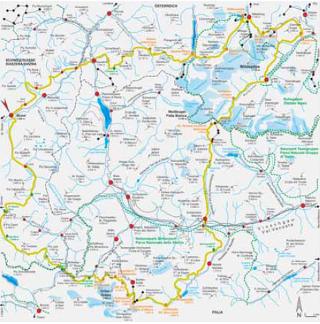

Dreiländerweg tour

Trailhead: Scoul (1215 m, bus and train connection)
Highest point: Passo Madriccio (3123 m)
Total travelling time: 89,5-97 h
Overall height gain/loss: + 14807 m - 14807 m
Alp Convention

Route descriptions: Walking the so called “Dreiländerweg” (“The three countries path”) you will not only cross Tyrol, the region of Alto Adige-Südtirol and the canton of Graubünden, but also the Austrian, Italian and Swiss borders, encountering very different cultures and environments. This 15-day trek across Samnaun, the Ötztal Alps, the Ortles-Cevedale massif, and the Mediterranean-looking landscape of the Ötztal Valley, you will be enthused by the diversity of scenery ranging from remote alpine valleys and glacial regions to green pastures. During the tour you will also walk through the Ötztal Natural Park, the Natural Park Gruppo di Tessa-Texelgruppe and the Stelvio National Park, and through well-developed tourist regions, such as the upper part of Pitztal and the ski area in Sölden, an indelible scar on this beautiful mountain environment. The “Bergsteigerdorf” Vent (the alpinists’ village), located in the far Ötztal, is an interesting place to visit. This is the place where, thanks to the priest Franz Senn, climbing in Tyrol really kicked off. There are big ascents and descents but all your effort will be rewarded, weather permitting, by breathtaking views: the Kalkalpen to the north, the Swiss three-thousanders to the west, and the unmistakable rock formations of the Dolomites to the south. The trailhead is the Swiss municipality of Scuol in the canton of Graubünden. You can also start from Nauders, Vent or Silandro- Schlanders. A 15-day tour may be too long for some people; therefore, this route has been designed in a such way that you can shorten it at different stages.

Skills required:A 15-day tour is very demanding and it can seriously test you fi tness. You will be walking on paths, roads and icy cols, it is therefore essential to bring the appropriate ice climbing gear. Equal importance should be given to the ability of walking at great heights. You will in fact reach or even exceed an altitude of 3,000 meters. It is essential to use careful footwork, have a head for heights and be really fit.

Touring around the Ötztal Alps, the Ortles-Cevedale Group and the Samnaun


Dreiländerweg tour

Trailhead: Scoul (1215 m, bus and train connection)
Highest point: Passo Madriccio (3123 m)
Total travelling time: 89,5-97 h
Overall height gain/loss: + 14807 m - 14807 m
Alp Convention

Scuol – Sent – Val Sinestra – Vnà – Tschlin


Travel time: 5,5-6 h.

From the Rhaeto-Roman town of Scuol (1250 m) initially follow the road, which is usually not very busy. A slightly ascending slope leads you to Sent, sitting above the Inn valley. Leave Sent and reach the Wirtshaus, go past the lively Brancla stream and, after about 3½ hours, you arrive at Vnà (1650 m), where you can stay overnight. After a further 2,5 hours you reach the small town of Tschlin (1559 m).

Accommodation:
Gast- und Kulturhaus Piz Tschütta (Vnà, 1650 m): Tel. +41--(0)81-8601212, e-mail: [email protected], www.hotelvna.ch, open all year, private.
For further information: Engadin Scuol Tourismus and Tschlin Tourismus.

Touring around the Ötztal Alps, the Ortles-Cevedale Group and the Samnaun


Dreiländerweg tour

Trailhead: Scoul (1215 m, bus and train connection)
Highest point: Passo Madriccio (3123 m)
Total travelling time: 89,5-97 h
Overall height gain/loss: + 14807 m - 14807 m
Alp Convention

Tschlin – Martina – Nauders

Travel time: 2,5-3 h

From Tschlin follow the Via Engadina path for about 1-1,5 hrs towards Martina. Cross the river Inn and take the road to the former customs post and cross the border into Tyrol. Climb up the path, not very well waymarked, and walk as far as Norbertshöhe (1461 m), continue towards Lochmühle and descend to Nauders (1394 m).

Accommodation:
For information: Tourismusverband Nauders.

Touring around the Ötztal Alps, the Ortles-Cevedale Group and the Samnaun


Dreiländerweg tour

Trailhead: Scoul (1215 m, bus and train connection)
Highest point: Passo Madriccio (3123 m)
Total travelling time: 89,5-97 h
Overall height gain/loss: + 14807 m - 14807 m
Alp Convention

Nauders – Tscheyjoch – Hohenzollern Haus

Travel time: 7,5-8 h

There are several trails connecting Nauders to Tscheyjoch, the most scenic one is the path crossing the Valeri valley going as far as the “Nauderer Höhenweg” path. Follow it till you arrive at an abandoned hut in Valdafur (2072 m). After gaining 500m you arrive at Tscheyjoch (2600 m) and then you continue uphill towards the ski area of Nauders. Leave Tscheyjoch and follow a path, again poorly waymarked, and descend to Nauderer Tscheytal. After a short ascent of 200 m, take the path running through the western crags of Muttler Kopf and Wildnörderer (3011 m), and descend to the Hohenzollern Haus (2120 m).

Accommodation:
Hohenzollern Haus (2120 m): Tel. +43-(0)664-5311915, open from the beginning of June to the end of September, DAV.

Touring around the Ötztal Alps, the Ortles-Cevedale Group and the Samnaun


Dreiländerweg tour

Trailhead: Scoul (1215 m, bus and train connection)
Highest point: Passo Madriccio (3123 m)
Total travelling time: 89,5-97 h
Overall height gain/loss: + 14807 m - 14807 m
Alp Convention

Hohenzollern Haus – Rotschragenjoch - Gepatschhaus

Travel time: 6,5-7 h

Even though today’s height gain is not so significant you will reach almost an altitude of 3000 m. Leave the Hohenzollern Haus (2120 m) and after a short distance, turn left on path 902. The path steepens as you near the Rotschragenjoch, where, most probably, you will need to use your hands to climb up. Take note of the broad basin in the Radurschltal valley with its numerous ice blocks amongst stones. After the Rotschragenjoch saddle, where there is a route to the Glockturm, you quickly descend to the Kaiserbergtal valley. Finally, head south; following the trail going over the Gepatschspeicher to the Gepatschhaus hut (1928 m).

Accommodation:
Gepatschhaus (1928 m): Tel. +43-(0)664-4319634 or +43-(0)5475-489, e-mail: [email protected], www.gepatschhaus.at, open from mid June to the end of September, DAV.

Touring around the Ötztal Alps, the Ortles-Cevedale Group and the Samnaun


Dreiländerweg tour

Trailhead: Scoul (1215 m, bus and train connection)
Highest point: Passo Madriccio (3123 m)
Total travelling time: 89,5-97 h
Overall height gain/loss: + 14807 m - 14807 m
Alp Convention

Gepatschhaus – Ölgrubenjoch – Taschachhaus – Fuldaer Höhenweg – Riffl seehütte

Travel time: 7-7,5 h.

The view you will see today is one you will never forget: the sea of ice in the Ötztal Alps. From the Gepatschhaus descend as far as the road, then follow the steep and tortuous path to Ölgrubenjoch (3050 m). Continue fl anking the Sexergetenferner till the Taschachhaus hut, where you can stop for food or stay overnight. There is also an impressive view of the Taschachferner and the Wildspitze (3770 m). On the “Fuldaer Höhenweg” path, you traverse open hillside until you reach the Riffl seehütte (2293 m) above the Taschachtal. On entering the exploited touristic area, you will be struck by the contrast with the surrounding natural landscape..

Accommodation:
Taschachhaus (2432 m): Tel. +43-(0)664-1384465, e-mail: [email protected], www.taschachhaus.com, open from mid June to the end of September, DAV.
Riffl seehütte (2293 m): Tel. +43-(0)5252-6474, open from mid June to the end of September, DAV.

Touring around the Ötztal Alps, the Ortles-Cevedale Group and the Samnaun


Dreiländerweg tour

Trailhead: Scoul (1215 m, bus and train connection)
Highest point: Passo Madriccio (3123 m)
Total travelling time: 89,5-97 h
Overall height gain/loss: + 14807 m - 14807 m
Alp Convention

Riffl seehütte – Mittelberg – Braunschweiger Hütte – Pitztaler Jöchl – Rettenbachalm – Gaislachalm

Travel time: 7,5-8 h

Leave the Riffl seehütte, walk down towards the valley and go past the cableway station of the Pitztal glacier. This route would offer really impressive scenery if it wasn’t for the so called “emergency path” for the skiing resort spoiling the Griesstal. Because of this path that connects the mountain to the valley, a once wild environment has lost much of its natural beauty. In some parts, the ascent to the Braunschweiger Hütte (2759 m) requires very careful footwork. Once you arrive at the hut you can enjoy a magnificent view of the Linker Fernerkogel. After a short reinvigorating break, quickly ascend to Pitztaler Jöchl (2996 m) then go all the way down to the ski area on the Rettenbachferner and eventually you reach Gaislachalm (1968 m).

Accommodation:
Braunschweiger Hütte (2759 m): Tel. +43-(0)664-5353722, e-mail: [email protected], www.braunschweiger-huette.at, open from mid June to the end of Septemebr, DAV.
Rettenbachalm (2138 m): Tel. +43-(0)5254-2622, private. Alpengasthof Gaislachalm (1,968 m): Tel. +43-(0)5254-2914, e-mail: [email protected], www.gaislachalm.com, open all year, private.

Touring around the Ötztal Alps, the Ortles-Cevedale Group and the Samnaun


Dreiländerweg tour

Trailhead: Scoul (1215 m, bus and train connection)
Highest point: Passo Madriccio (3123 m)
Total travelling time: 89,5-97 h
Overall height gain/loss: + 14807 m - 14807 m
Alp Convention

Gaislachalm – Vent

Travel time: 5-5,5 h

After two hours walking uphill towards the Tiefenbachferner car park, you then cross beautiful pastures in the Ventertal. Follow the road directing you to Vent (Bergsteigerdorf, the climber’s village) (1895 m).

Accommodation:
For information: Ötztal Tourismus-Büro Vent.

Touring around the Ötztal Alps, the Ortles-Cevedale Group and the Samnaun


Dreiländerweg tour

Trailhead: Scoul (1215 m, bus and train connection)
Highest point: Passo Madriccio (3123 m)
Total travelling time: 89,5-97 h
Overall height gain/loss: + 14807 m - 14807 m
Alp Convention

Vent – Rofen – Hochjoch-Hospiz – Gasthof Schöne Aussicht – Maso Corto-Kurzras

Travel time: 6,5-7 h

From Vent walk up to Rofen (2014m), the highest permanent settlement in the Eastern Alps. Cross the Rofental and take the easy uphill slope to Hochjoch-Hospitz (2413 m). After a short break, lose about 120 m and reach Rofenbach. The path then continues up in parallel to the Hochjochferner, where you enter Italy through a former customs post. From here you soon reach Schöne Aussicht/Bellavista (2842 m). Finally you enter the popular tourist town of Maso Corto-Kurzras (2010 m).

Accommodation:
Hochjoch-Hospiz (2413 m): Tel. +43-(0)676-6305998, e-mail: [email protected], open from the end of June to the end of September, DAV.
Gasthof Schöne Aussicht-Bellavista (2842 m): Tel. +39-0473-662140, e-mail: [email protected], www.schoeneaussicht.it, open from the end of June to the beginning of October, private.

Touring around the Ötztal Alps, the Ortles-Cevedale Group and the Samnaun


Dreiländerweg tour

Trailhead: Scoul (1215 m, bus and train connection)
Highest point: Passo Madriccio (3123 m)
Total travelling time: 89,5-97 h
Overall height gain/loss: + 14807 m - 14807 m
Alp Convention

Maso Corto-Kurzras – Silandro-Schlanders

Travel time: 6-6,5 h

From Maso Corto-Kurzras (2010 m) walk past the stream and go along the Kofl erberg in the lonely valley of Lagauntal. Gain about 500 m and reach Tascheljöchl (2765 m), where you fi nd the ruins of the Heilbronner Hütte. As you start descending, you go past Lake Nero/Schwarze Lacke and Lake Còrzes/Kortscher See (2501 m). After the Kortscher Alm follow the ancient paths of the irrigation ditches (Waalwege). Traverse the valley of Silandro-Schlandrauner Tal, and you arrive at the municipality of Silandro- Schlanders (738 m).

Accommodation:
For information: Associazione Turistica Val Senales - Tourismusverein Schnalstal Associazione Turistica Val Venosta/Silandro- Tourismusverband Vinschgau/Schlanders.

Touring around the Ötztal Alps, the Ortles-Cevedale Group and the Samnaun


Dreiländerweg tour

Trailhead: Scoul (1215 m, bus and train connection)
Highest point: Passo Madriccio (3123 m)
Total travelling time: 89,5-97 h
Overall height gain/loss: + 14807 m - 14807 m
Alp Convention

Silandro-Schlanders – Hotel Waldheim

Travel time: 5,5-6 h

Today’s journey will take you up to 1700 m and will reward you with an absolutely stunning view of the Ortles-Cevedale range. From Silandro-Schlanders go to Covelano- Göfl an and after you cross the Adige river walk up to Morterleger (1700 m). From here, follow the path squeezing through the rocks as it leads you to Steinwandhof (1464 m) followed by Oberhof (1494 m). Ascend to Sambuchi di sopra/Ober-Hölderle (1627 m), overlooking Val Martello/Martelltal and then, after a short descent, you reach the Hotel Waldheim (1556 m).

Accommodation:
Hotel Waldheim (1556 m): Tel. +39-0473-744545, e-mail: [email protected], www.waldheim.info, open all year, private.

Touring around the Ötztal Alps, the Ortles-Cevedale Group and the Samnaun


Dreiländerweg tour

Trailhead: Scoul (1215 m, bus and train connection)
Highest point: Passo Madriccio (3123 m)
Total travelling time: 89,5-97 h
Overall height gain/loss: + 14807 m - 14807 m
Alp Convention

Hotel. Waldheim – Gasthof Enzian – Rif. Nino Corsi-Zufallhütte – Rif. Città di Milano-Schaubachhütte

Travel time: 5-5,5 h

Today the journey is of considerable length and it is therefore divided into three stops. From the Hotel Waldheim walk up to Schluderalm and follow the path directing you to Lyfialm (2165m). From here, descend to the Gasthof Enzian (2051 m) or to the Rif. Nino Corsi-Zufallhütte (2265 m), where you can stay overnight. Walk up the Martell valley towards the Rif. Nino Corsi -Zufallhütte and then branch west, following the Val Madriccio-Madritschtal until you reach the Passo Madriccio- Madritschjoch (3123 m). From here you can enjoy a panorama of Gran Zebrù- Königspitze, Monte Zebru and Ortles. Finally, descend by following the cableway all the way to the hut Città di Milano-Schaubachhütte (2581 m).

Accommodation:
Gasthof Enzian (2051 m): Tel. +39-0473-744755.
Rif. Nino Corsi-Zufallhütte (2264): Tel. +39-0473-744785, e-mail: [email protected], www.zufallhuette.com, open from mid June to mid October, private.
Rif. Città di Milano-Schaubachhütte (2581 m): Tel. +39-0473-613024, e-mail: info@schaubachhütte.it, www.schaubachhuette.it, open from the mid of June to the end of September, CAI.

Touring around the Ötztal Alps, the Ortles-Cevedale Group and the Samnaun


Dreiländerweg tour

Trailhead: Scoul (1215 m, bus and train connection)
Highest point: Passo Madriccio (3123 m)
Total travelling time: 89,5-97 h
Overall height gain/loss: + 14807 m - 14807 m
Alp Convention

Rif. Città di Milano-Schaubachhütte – Rif. Coston-Hintergrathütte – Rif. Tabaretta – Bärenkopfjoch – Rif. Borletti-Berglhütte

Travel time: 5,5-6 h

This is the most beautiful day on the tour, because you will have a view of Cevedale, the Königspitze, Monte Zebru and Ortles all at the same time. It starts with a gentle ascending slope towards the Rif. Coston-Hintergrathütte (2661 m) which rises quickly gaining about 300 m as you reach the K2 hut. As you walk up to the Tabaretta hut (2550 m) you see a stone in memory of all the climbers who died while climbing the Ortles. The path then unfolds and start climbing up towards the Bärenkopfjoch (2938 m) and from here you have one last strenuous descent to the Rif. Borletti-Berglhütte (2188 m).

Accommodation:
Rif. Coston-Hintergrathütte (2661 m): Tel. +39-0473-613188, open from the beginning of July to the end of September, private.
Rif. Tabaretta (2550 m): Tel. +39-347-2614872, open from the beginning of June to mid October, private.
Rif. Borletti-Berglhütte (2188 m): Tel. +39-338-3877344, e-mail: [email protected], www.berglhuette.it, open from the beginning of June to mid October, CAI.

Touring around the Ötztal Alps, the Ortles-Cevedale Group and the Samnaun


Dreiländerweg tour

Trailhead: Scoul (1215 m, bus and train connection)
Highest point: Passo Madriccio (3123 m)
Total travelling time: 89,5-97 h
Overall height gain/loss: + 14807 m - 14807 m
Alp Convention

Rif. Borletti-Berglhütte – Berghotel Franzenshöhe – Passo dello Stelvio-Stilfser Joch – Rif. Garibaldi-Dreisprachenspitze – Berghaus Astras – Umbrailpass

Travel time: 5,5-6 h

Descend to the Trafoi/Trafoiertal valley, cross the stream and reach the Berghotel Franzenshöhe (2188 m). The two uphill slopes to Pass Stelvio-Stilfser Joch (2757 m) and to the summit Garibaldi-Dreisprachenspitze (2843 m) are easy and very scenic. You eventually reach Pass Ubrail (2503 m) where you can choose between Italy and Switzerland for your overnight stay.

Accommodation:
Berghotel Franzenshöhe (2188 m): Tel. +39-0473-611768, e-mail: [email protected] www.franzenshoehe.com, open from the end of May to October, private.
Rif. Garibaldi-Dreisprachenspitze (2845 m): Tel. +39-0342-904312, e-mail: [email protected], www.rifugiogaribaldi.it, open from June to October, private.
Berghaus Astras (2503 m): Tel. +41-(0)81-8585782, e-mail: [email protected], open from May to October, private.

Touring around the Ötztal Alps, the Ortles-Cevedale Group and the Samnaun


Dreiländerweg tour

Trailhead: Scoul (1215 m, bus and train connection)
Highest point: Passo Madriccio (3123 m)
Total travelling time: 89,5-97 h
Overall height gain/loss: + 14807 m - 14807 m
Alp Convention

Umbrailpass – Piz Umbrail – Lai da Rims – Alp Mora – Passo del Forno-Ofenpass

Travel time: 7,5-8 h

Today’s route is long and it will not be possible to stop for a break. Start the journey by climbing up to Piz Umbrail (3031 m). The subsequent descent takes you first to the beautiful lake Lai da Riems-Bergsee and then to Alpe Clastra. At this point you are amongst the three-thousanders as you walk up for a short distance and then descend again to Alpe Mora (2084 m). Cross the saddle and at almost 2300 m you reach Passo del Forno-Ofenpass (2149 m).

Accommodation:
Hotel Süsom Give (2149 m): Tel. +41-(0)81-858582, e-mail: [email protected], open all year, private.

Touring around the Ötztal Alps, the Ortles-Cevedale Group and the Samnaun


Dreiländerweg tour

Trailhead: Scoul (1215 m, bus and train connection)
Highest point: Passo Madriccio (3123 m)
Total travelling time: 89,5-97 h
Overall height gain/loss: + 14807 m - 14807 m
Alp Convention

Passo del Forno-Ofenpass – Funt da S-charl – Alp Astras – S-charl – Scuol

Travel time: 6,5-7 h

This is the last day of the tour and so enjoy it to the full. The fi rst uphill slope to Funt da S-charl is short and it is followed by an incredibly stunning descent towards the S-charl-Tal valley and the Clemgia stream. Go past the town of S-charl, and follow the path as it squeezes through a narrow road and then unfolds gently all the way to Scuol (1250 m).

Accommodation:
For information: Engadin Scuol Tourismus.

Touring around the Ötztal Alps, the Ortles-Cevedale Group and the Samnaun


Dreiländerweg tour

Trailhead: Scoul (1215 m, bus and train connection)
Highest point: Passo Madriccio (3123 m)
Total travelling time: 89,5-97 h
Overall height gain/loss: + 14807 m - 14807 m
Alp Convention

Useful information

Tourist information
Engadin Scuol Tourismus: Tel. +41-(0)81-8612222 e-mail: [email protected], www.scuol.ch.
Tschlin Tourismus: Tel. +41(081)- 8663303 e-mail: [email protected], www.tschlin.ch
Tourismusverband Nauders: Tel. +43-(0)5473-87220 e-mail: [email protected], www.nauders.info
Ötztal Tourismus-Büro Vent: Tel. +43-(0)57200-260 e-mail: [email protected], www.vent.at
Associazione Turistica Val Senales - Tourismusverein Schnalstal: Tel. +39-0473-679148 e-mail: [email protected], www.oetzisworld.it
Associazione Turistica Val Venosta/Silandro- Tourismusverband Vinschgau/Schlanders: Tel. +39-0473-620480 e-mail: [email protected], www.vinschgau-suedtirol.info

Alpine Guides
Bergführerstelle Vent: Tel. +43-(0)5254-8106 e-mail: [email protected], www.bergfuehrer-vent.at
Bergführer Unterengadin, Planta Tumasch: Tel. +41-(0)81-8649071 and Egler Jachen Tel. +41-(0)81-8641916
Alpinschule Ortler, Haus der Berge: Tel. +39-0473-613004 e-mail: [email protected], www.alpinschule-ortler.com

Parks
Naturpark Ötztal: Tel. +43-(0)525-622957 e-mail: [email protected], www.naturpark-oetztal.at
Parco Naturale Gruppo di Tessa-Texelgruppe: Tel. +39-0473-668201, e-mail: [email protected], www.provinz.bz.it/natur/2803/index_i.asp
Stelvio National Park: Tel. +39-0342-910100 e-mail: [email protected], www.stelviopark.it

Maps
Ötztaler Alpen: Nauderer Berge: 1:25.000
Map Alpenvereinskarte Nr. 30/5 Ötztaler Alpen: Geigenkamm: 1:25.000
Map Alpenvereinskarte Nr. 30/6 Ötztaler Alpen: Wildspitze: 1:25.000
Map Tabacco Sheet 08 Ortlergruppe- Cevedale: 1:25.000
Map Tabacco Sheet 45 Latsch-Laces Martell- Val Martello Schlanders-Silandro: 1:25.000
National map of Switzerland, Sheet 259 Ofenpass: 1:50.000
National map of Switzerland, Nauders: 1:50.000
National map of Switzerland, Sheet 249 Tarasp: 1:50.000

Alpine clubs
Oesterreichischer Alpenverein (OeAV): Tel. +43-(0)512-59547-0 e-mail: [email protected], www.alpenverein.at
Club Alpino Italiano (CAI): Gruppo Regionale Alto Adige Tel. +39-0471-402144 e-mail: [email protected], www.caialtoadige.it
Alpenverein Südtirol (AVS): Tel. +39-0471-978141 e-mail: [email protected], www.alpenverein.it
Swiss Alpine Club (SAC-CAS): Tel. +41-(0)31-3701818 e-mail: [email protected], www.sac-cas.ch
Deutscher Alpenverein (DAV): Tel. +49-(0)89-14003-0 e-mail: [email protected], www.alpenverein.de

Weather Switzerland: +41-(0)900-162 333 www.meteoschweiz.admin.ch
Austria: www.zamg.ac.at
Personal enquiries: Tel. +43-(0)512-291600 (Mon-Sat 13-18 h)
Province of Bolzano: www.provincia.bz.it/meteo

Public transport:
Rhaetic Railway: Tel. +41-(0)812-884340 www.rhb.ch
PostBus Switzerland: Postauto Graubünden Tel. +41-(0)81-8641683, www.postauto.ch/de
ÖBB-Postbus GmbH: Tel. 0810-222333 Tel. +43-(0)1-71101 (from abroad, daily from 07.00 to 20.00 h), www.postbus.at
Integrated Transport in Alto Adige-Südtirol: Tel. +39-0471-450111, www.sad.it

Websites
www.alparc.org
www.via-alpina.org
  • BOOK YOUR TRIP
    Tell us your wants and needs and we will try to plan you the perfect trip

    BOOK

  • CONTACT US
    Please, write to us and ask us your questions, and we will get back to you.

    CONTACT US