Trekking in the Alps

In this section we present a chapter from the book "Per Alpes, Discovering the Alps in 20 circular walks". Read the tour description below and check other publications of the Alps Convention.

  • Maritime Alps tour
  • Day 1
  • Day 2
  • Tourist info

The enchanting Dolomites

Civetta tour

Trailhead: Rif. Palafavera/Rif. M. Pelmo (1525 m, bus connections from Belluno/Longarone)
Highest point: Forc delle Sasse (2476m)
Total travelling time:12-13h
Overall height gain/loss: +16418m - 1641m
Alp Convention

Route descriptions: The Dolomites are amongst the most magnificent mountain ranges of the alpine area. Thanks to their beauty, unique landscapes, geological and geomorphic significance, in June 2009 the Dolomites became a UNESCO World Heritage site. None of the Dolomites peaks are alike: dizzying rock overhangs, rocks of many different colours and sharp pointed stones which seemingly defy gravity, deep, populated valleys surrounded by lush pastures, and a thriving alpine flora. Only if you have crossed the Dolomites in their entirety and appreciated their beauty and diversity to the full, can you claim to know them well. One particular mountain stands out of the entire range: the Civetta, reaching 3220m, a gigantic monolith with steep cliffs towering over one thousand meters. If you think this mountain to be a playground for climbers only, you are mistaken. Believe it or not, amongst this labyrinth of rocks hides an incredible amount of trails that can be tackled by trekkers without major difficulties.

Skills required:Unlike many of the ascents to the main peaks in the Dolomites, which are usually high and sharp, the tour of Civetta does not require great climbing skills. However, you must never underestimate the Dolomites, since they are never short of sharp crests and sometimes friable and/or unstable rocks. Needless to say, careful footwork, head for heights, and confidence are really important. This tour, however, is also suitable for those who are fairly new to trekking, because you do not need to use any equipment and the length is not too demanding.

The enchanting Dolomites


Civetta tour

Trailhead: Rif. Palafavera/Rif. M. Pelmo (1525m, bus connections from Belluno/Longarone)
Highest point: Forc delle Sasse (2476m)
Total travelling time:12-13h
Overall height gain/loss: +16418m - 1641m
Alp Convention

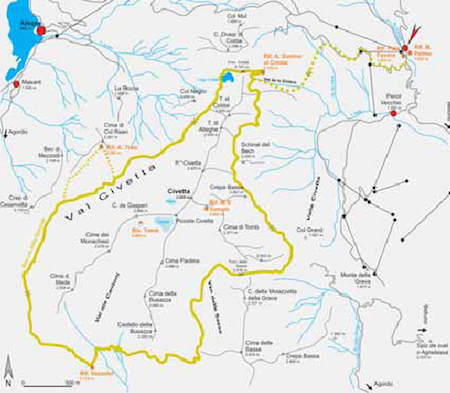
Rif. Palafavera/Rif. Monte Pelmo – Casera di Pioda – Val de le Ziolere – Rif. Sonino al Coldai – Forc. Coldai – Lago Coldai – Forc. del Col Negro – Rif. A. Tissi – Cason di Col Reàn – Sella di Pelsa – Casa Favretti – Rif. M. Vazzoler


Travel time: 6-6,5h.

At the extreme southern end of the large car park (1525m) follow the path 564 till you reach approximately 1735m altitude and instead of going up col Alleghe, head south as far as Casera di Pioda. Below the north face of the Torrioni delle Ziolere the path takes you across the Valle de le Ziolere (valley) all the way to the Sonino al Coldai (2132m) hut. After a short ascent to the Coldai saddle (2191m), follow the Alta Via delle Dolomiti route leading you directly to Lake Coldai (2143m). From here, a new path gains about 60m to the Col Negro saddle (2203m). As you walk along the Alta Via, you will surely notice the incredible size of the Civetta’s face, rising over a thousand meters. Once you are on the highland of Val Civetta you can either choose to go directly to the Col Reàn saddle (2107m) or opt for a longer, but more interesting route stopping by the Tissi hut (2260m) for a short break. Leave the Tissi hut and get back on the Alta Via delle Dolomiti leading you to Sella di Pelsa (1954m) and the M. Vazzoler hut (1714m).

Accommodation:
Rif. M. Pelmo (1525m): Tel. +39-0437-789359, open all year, private.
Rif. Palafavera (1525m): Tel. +39-0437-789472, e-mail: [email protected], www.palafavera.com, open all year, private.
Rif. A. Sonino al Coldai (2132m): Tel. +39-0417-16900 or +39-0437-789160, open from mid June to the end of September, CAI. Rif. A. Tissi (2260m): Tel. +39-0437-931655 or +39-0437-721644, open from the end of June till the end of September, CAI.
Rif. M. Vazzoler (1714m): Tel. +39-0438-24041 or +39-0437-660008, open from mid June to mid September, CAI.

The enchanting Dolomites


Civetta tour

Trailhead: Rif. Palafavera/Rif. M. Pelmo (1525m, bus connections from Belluno/Longarone)
Highest point: Forc delle Sasse (2476m)
Total travelling time:12-13h
Overall height gain/loss: +16418m - 1641m
Alp Convention

Rif. M. Vazzoler – Covol delle Sasse – Van delle Sasse – Forc. delle Sasse – Anello Zoldano n. 557 – Rif. A. Sonino al Coldai – Rif. Palafavera/Rif. M. Pelmo

Travel time: 6-6,5h

Today you are going to pass right below the track of the very popular and demanding “Via Ferrata degli Alleghesi”, which runs on the eastern crest for 900m and goes all the way to the peak of Civetta (3220m). Every year many climbers try to tackle this mountain, often underestimating the challenge it presents. From the M. Vazzoler hut (1714m) steadily walk up to Covol delle Sasse (2061m). Follow trail 558, to reach the stunning “Van delle Sasse” basin that lies between the Civetta and Cima delle Sasse. Go ahead on the same trail to the Forcella delle Sasse col (2476m), the highest point in the tour. The path leads you to the north-eastern crags of Cima di Tomb and the massive eastern face of the Civetta. Here the via ferrata begins, running along the Anello Zoldano 557 and leading you directly to the Sonino al Coldai hut. After a short break you can start descending back to the trailhead and either the Palafavera or M. Pelmo hut.

Accommodation:
Rif. A. Sonino al Coldai (2132m): check Day 1.
Rif. M. Pelmo (1525m): check Day 1.
Rif. Palafavera (1525m): check Day 1.

The enchanting Dolomites


Civetta tour

Trailhead: Rif. Palafavera/Rif. M. Pelmo (1525m, bus connections from Belluno/Longarone)
Highest point: Forc delle Sasse (2476m)
Total travelling time:12-13h
Overall height gain/loss: +16418m - 1641m
Alp Convention

Useful information

Tourist information
Dolomiti Turismo S.r.l.: Tel. +39-0437-940084 e-mail: [email protected], www.infodolomiti.it.
Ufficio Turistico di Zoldo Alto: Tel. +39-0437-789145, e-mail: [email protected]www.infodolomiti.it
Consorzio Val Zoldana: Tel. +39-0437-788907 e-mail: [email protected], www.val-zoldana.com

Alpine Guides
Guide Alpine Val di Zoldo: Tel +39-328-2170815 or +39-347-2990255 e-mail: [email protected], www.guidealpinevaldizoldo.it
Guide alpine Agordine: Tel. +39-0437-592144
Guide alpine Val Fiorentina: Tel. +39-0437-720248 e-mail: [email protected]www.valfiorentina.it/selva/ at/estate/oltre/guide.htm
Zero8mila: Tel. +39-339-2201656 e-mail: [email protected], www.zero8mila.it

Parks
Parco Nazionale delle Dolomiti Bellunesi: Tel. +39-0439-3328, Fax +39-0439-332999 e-mail: [email protected], www.dolomitipark.it
Weather
Arpav – Dolomiti Meteo: Tel. +39-0436-755711, www.arpa.veneto.it/bollettini/htm/dolomitimeteo.asp
Meteo audio: Tel. +39-0436-780007
Italy: www.meteo.it, www.meteoitalia.it, www.meteoam.it

Maps
Map Tabacco, Sheet 015 Marmolada – Pelmo – Civetta – Moiazza: 1:25.000
Map Tabacco, Sheet 025 Dolomiti di Zoldo, Cadorine e Agordine: 1:25.000
Map Meridiani Montagne: Civetta – carta: 1:25.000 and detailed map 1:10.000

Alpine clubs
Club Alpino Italiano (CAI), Sezione Val di Zoldo: Tel +39-0437-78100, e-mail: [email protected]

Public transport
Dolomitibus: www.dolomitibus.it

Websites
www.alparc.org
www.dolomiti.org
whc.unesco.org/en/list/1237

  • BOOK YOUR TRIP
    Tell us your wants and needs and we will try to plan you the perfect trip

    BOOK

  • CONTACT US
    Please, write to us and ask us your questions, and we will get back to you.

    CONTACT US